Tools & Applications

Webservice-Energy enable access to energy-related visualizations tools, apps and WebGIS client. Select them in the gallery below.

Tools & Applications Gallery

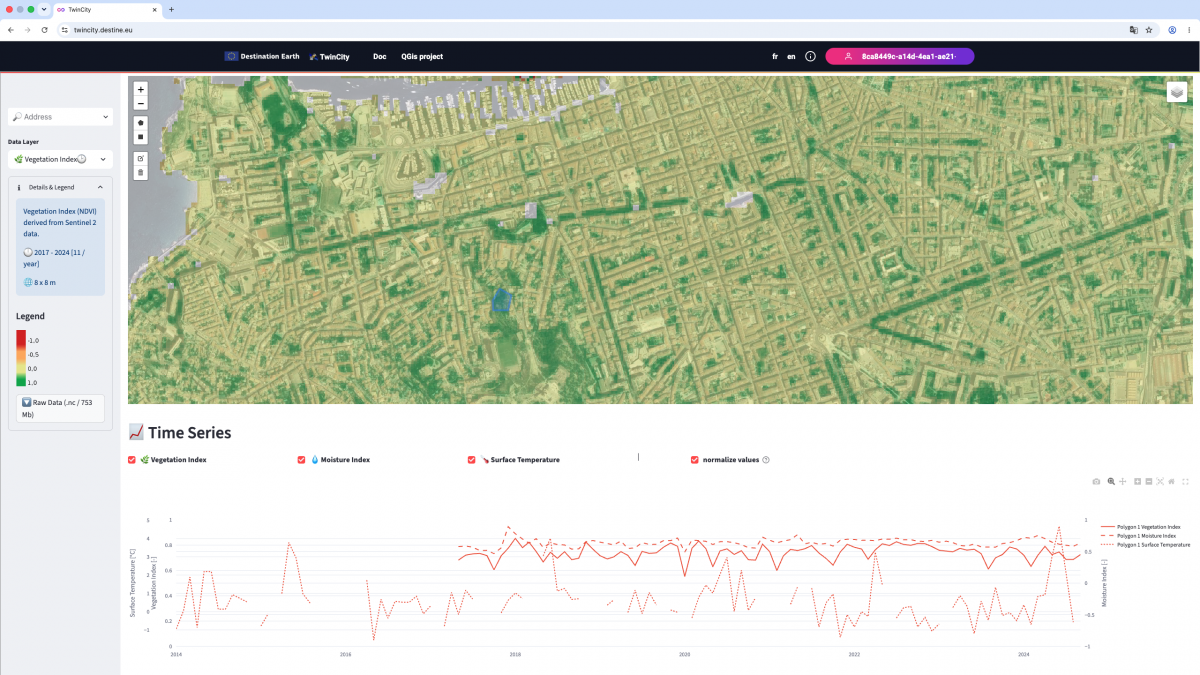
The TwinCity WebGIS application (https://twincity.oie-lab.net/) is the result of a co-design effort carried out by MINES Paris PSL and the City of Marseille within the framework of the ESA-funded Destination Earth (DestinE) project.

Hosted and operated by the Webservice-Energy Information Spatial Data Infrastructure (SDI), the application provides municipal teams with high-resolution Earth Observation data that support their operational activities in areas such as green space management, urban planning, and energy management.

TwinCity follows FAIR principles and relies on open-source technologies and international standards, including OGC standards. The platform enables users to access and exploit data through two complementary interfaces:

  • A WebGIS client that allows users to easily visualize datasets and generate useful statistics and indicators;
  • A QGIS project providing direct access to the underlying raw data, which are exposed as web services (OGC WMS) through a GeoServer infrastructure.

This dual-access approach facilitates both straightforward data exploration by non-specialist users and advanced analysis by GIS professionals.

Web Service Type: 

This application provides access to in-situ data from stations of various networks.

http://viewer.webservice-energy.org/in-situ/

In is a web frontend to a Thredds Data Server (TDS) in which data are stored in NetCDF format with proper meta-data encoding following Climate and Forecast (CF) Conventions.

This interface allows you to dynamically locate the stations on a map, visualize data on charts and download the raw NetCDF data, or subsets in JSON or CSV.

Access to measurements time-series are either fully open or available on a restricted access base. For more infomation contact Lionel Menard.

Web Service Type: 

Access to land and marine data from models, satellites and in-situ measurements in NetCDF format with CF compliant metadata from a Thredds Data Server (TDS) tds.webservice-energy.org

Thredds Data Server (TDS)

Web Service Type: 

ENVI-PV is a web-based interactive service to assess the current and prospective (2050) environmental performance of manufacturing, transportation and use of photovoltaic systems at screening level based on reference Photovoltaic (PV) systems. Maps of screening level PV environmental performances are provided for a worldwide coverage.

Environmental performance tool for PV systems


Copernicus Atmosphere Monitoring Service (CAMS) includes:

CAMS McClear: A time-series of solar radiation that would be received on a horizontal plane at ground level if the sky were clear.

CAM Radiation: A service provides time series of Global, Direct, and Diffuse Irradiations on horizontal surface, and Direct Irradiation on normal plane (DNI) for the actual weather conditions as well as for clear-sky conditions.

 
Web Service Type: 

The Global Atlas is the comprehensive information platform on the potential of renewable energy. It provides resource maps from leading technical institutes worldwide and tools for evaluating the technical potential of renewable energies. It can function as a catalyst for policy development and energy planning, and can support investors in entering renewable energy markets. Access to the WebGIS Client